A Vision for Queens' Version of the High Line
Earlier this week, the Trust for Public Land and Friends of the QueensWay detailed its plans to transform a 3.5-mile stretch of abandoned railway in Queens into New York City’s newest marquee park, touting the plan as a boon for local businesses and residents alike.
Plans for the QueensWay call for turning an inaccessible area at its northern end into a small park featuring a playground and rain gardens to reduce flooding in heavy rain.
The plans, created by WXY Architecture & Urban Design and DlandStudio Architecture & Landscape Architecture, include a mix of new recreational and cultural opportunities as well as natural trails that supporters say will transform this section of the former Rockaway Beach branch of the Long Island Railroad into Queens’ own version of Manhattan’s High Line. The park would straddle the neighborhoods of Forest Hills, Ozone Park, Rego Park, Richmond Hill, and Woodhaven.

Recreation areas would be added atop the QueensWay's elevated section, while pathways would connect commuters to the A subway line.
The project faces significant hurdles. For starters, some Queens residents would rather see a restoration of rail service to the Rockaways while others have raised concerns about privacy. And then there is the matter of money. Proponents estimate that it will cost $120 million to build the park. The New York Times reported this week that the Trust for Public Land has raised $1.2 million for the project, including $467,000 in New York State park funds. That signals that a challenging fundraising effort lies ahead.
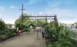
The viaduct between Atlantic and Liberty avenues in Ozone Park will feature new walkways, seating areas, and a bike bath.
Still, supporters of the plan are optimistic.
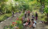
A rendering of the QueensWay as it would appear near Metropolitan Avenue. Supporters say the QueensWay would provide safe walkways and bike paths for easier access to shopping areas and Forest Park, in addition to creating outdoor learning areas for three nearby schools.
"This will be a wonderful park for Queens," says Will Rogers, president of the Trust for Public Land. "It will provide a safe way for people to get to Forest Park without having to cross dangerous traffic, and the visitors of the QueensWay will help local businesses. It will also provide outdoor recreation for thousands of people who need that access. We look forward to making this park a reality."
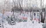
The QueensWay would run below grade for nearly a mile through Forest Park. Currently overgrown and unused, this section, called the ravine, would provide opportunities for year-round recreation.
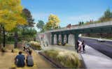
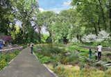
An inaccessible, overgrown space on Yellowstone Boulevard could become an access point to the QueensWay, with seating, landscaped plantings, and a small play area and garden.
Published
Last Updated
Get the Dwell Newsletter
Be the first to see our latest home tours, design news, and more.