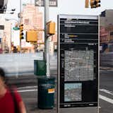
How New York City Developed its Wayfinding Signage
Dwell: First off, when did modern wayfinding come about? What large-scale historic and present-day wayfinding projects did you research and how did these inform the WalkNYC plan?
Michael Bierut: Wayfinding is as old as mapmaking, and maps of New York go back almost to its first European settlements.
There were probably three useful precedents for the work we did on Walk NYC. First were a series of urban wayfinding programs in Great Britain that many of our team members, including CityID and T-Kartor, have been involved with over the years.
Second was a wayfinding system I worked on for the downtown New York business district back in the '90s. This was, at the time, the largest single coordinated wayfinding program in New York City and we learned a lot, not only about how people navigate a complex urban district, but what you have to deal with when you install things like maps on the streets of New York in terms of regulations and maintenance.
Finally, there were the graphics that Unimark did for the
New York subway system in the late sixties and early seventies. I worked for Massimo Vignelli at the start of my career, and I was always impressed by the way the Unimark system managed to superimpose an abstract visual logic on a city that seems so illogical at every turn. WalkNYC attempts to do the same thing.