Diagrams that Changed City Planning
3 of 10
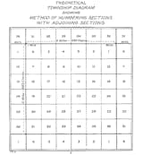
According to Grant's essay, "The Public Land Survey System (1785) divided U.S. land west of the Ohio River into 'townships' and 'sections' on a repeating grid, later shaping settlement patterns."
According to Grant's essay, "The Public Land Survey System (1785) divided U.S. land west of the Ohio River into 'townships' and 'sections' on a repeating grid, later shaping settlement patterns."