A Cartography Exhibition Uncovers Fascinating Maps About the Bay Area
1 of 7
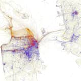
The SPUR exhibition Urban Cartography, which is open until February 6, 2015, documents mapmaking in the past twenty years. Eric Fischer's map, one of the myriad pieces on view, documents where locals and tourists in San Francisco take photographs using geotagged images from Flickr and Picasa. Blue signifies locals, red is tourists, and yellow could be either. "His maps are gorgeous," says Allison Arieff, SPUR's editorial director and the show's curator. "It's not immediately apparent what they are showing but a little explanation goes a long way."