Collection by Aaron Britt
Diagrams that Changed City Planning
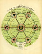
From now until February 15, SPUR in San Francisco is holding a rather interesting exhibition on the charts, diagrams, and visualizations that have changed the face of urban planning. From Ebenezer Howard's drawings of a garden city to an alarming graph showing our planet's rising temperature, Grand Reductions: Ten Diagrams That Changed City Planning takes a look at the images that have shaped our urban landscape. Equal parts art, design, and inspiring calls to action, the diagrams on view each offer a vision not just of where our thinking about cities has been, but how we might continue to mold them in the future. To read more, check out Benjamin Grant's fascinating essay on the subject in SPUR's publication the Urbanist.
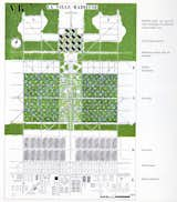
Le Corbusier also favored significant green space in cities, though his highly rationalist vision, articulated in this 1935 image of a "Radiant City," put residents in massive towers and sought to clean up the city's messy vitality.
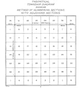
According to Grant's essay, "The Public Land Survey System (1785) divided U.S. land west of the Ohio River into 'townships' and 'sections' on a repeating grid, later shaping settlement patterns."
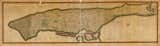
This 1811 Commissioner's Plan for Manhattan sought to regularize the colliding grids that had formed south of Houston St.
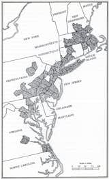
Jean Gottman's 1961 book Megalopolis argued that the Eastern seaboard could be seen as one massive interconnected urban corridor.
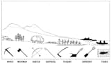
"Valley Section" by Patrick Geddes from 1909 offers a vision of not how a city might be laid out, but of what kind of work the land might offer. It's a naturalistic approach, though not one that has ultimately come to define large urban centers.
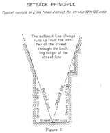
Here's Grant again: "Like many early planning codes, New York City’s 1916 Zoning Resolution established Euclidean zoning that regulated land use, defining residential, commercial, and industrial zones. But unlike many such laws, it also regulated the 'building envelope,' or the allowable volume that a structure could occupy."
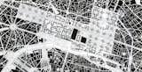
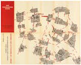
Theorist Guy Debord’s 1957 Guide Psychogeographique de Paris offers a wholly other vision of the city, a highly individual, even expressionistic map of a wander around town. Irrational in the extreme, Debord and his Situationist cohort embraced the complexities and unsavory corners of citylife.
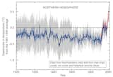
Dubbed the "Hockey Stick," Michael Mann's diagram shows the Earth's mounting temperature over the years.